


Weld 237, Weld County, Colorado
About
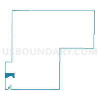
Outline

Summary
| Unique Area Identifier | 549362 |
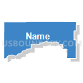
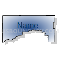
| Name | Weld 237 |
| County | Weld County |
| State | Colorado |
| Area (square miles) | 24.10 |
| Land Area (square miles) | 22.48 |
| Water Area (square miles) | 1.62 |
| % of Land Area | 93.28 |
| % of Water Area | 6.72 |
| Latitude of the Internal Point | 40.17972530 |
| Longtitude of the Internal Point | -104.98994720 |
Maps


Graphs
Select a template below for downloading or customizing gragh for Weld 237, Weld County, Colorado


Neighbors
Neighoring Voting District (by Name) Neighboring Voting District on the Map
- Boulder 183, Boulder County, CO
- Boulder 197, Boulder County, CO
- Boulder 213, Boulder County, CO
- Boulder 225, Boulder County, CO
- Boulder 229, Boulder County, CO
- Boulder 230, Boulder County, CO
- Boulder 234, Boulder County, CO
- Boulder 30, Boulder County, CO
- Weld 201, Weld County, CO
- Weld 202, Weld County, CO
- Weld 206, Weld County, CO
- Weld 207, Weld County, CO
- Weld 208, Weld County, CO
- Weld 239, Weld County, CO
- Weld 240, Weld County, CO
- Weld 300, Weld County, CO
Top 10 Neighboring County Subdivision (by Population) Neighboring County Subdivision on the Map
- Longmont CCD, Boulder County, CO (99,942)
- Erie-Frederick CCD, Weld County, CO (37,786)
- Johnstown-Milliken CCD, Weld County, CO (25,317)
- Platteville CCD, Weld County, CO (4,222)
Top 10 Neighboring Place (by Population) Neighboring Place on the Map
Top 10 Neighboring Unified School District (by Population) Neighboring Unified School District on the Map
- St. Vrain Valley School District RE 1J, CO (151,981)
- Weld County School District RE-8, CO (12,408)
- Weld County School District RE-1, CO (8,930)
Top 10 Neighboring State Legislative District Lower Chamber (by Population) Neighboring State Legislative District Lower Chamber on the Map
- State House District 48, CO (112,104)
- State House District 11, CO (80,189)
- State House District 13, CO (69,892)
- State House District 12, CO (69,766)
Top 10 Neighboring State Legislative District Upper Chamber (by Population) Neighboring State Legislative District Upper Chamber on the Map
- State Senate District 23, CO (188,398)
- State Senate District 17, CO (141,285)
- State Senate District 18, CO (122,287)
Top 10 Neighboring 111th Congressional District (by Population) Neighboring 111th Congressional District on the Map
Top 10 Neighboring Census Tract (by Population) Neighboring Census Tract on the Map
- Census Tract 21.03, Weld County, CO (8,009)
- Census Tract 134.02, Boulder County, CO (7,573)
- Census Tract 135.08, Boulder County, CO (6,575)
- Census Tract 132.11, Boulder County, CO (5,612)
- Census Tract 20.20, Weld County, CO (4,990)
- Census Tract 18, Weld County, CO (4,222)
- Census Tract 20.19, Weld County, CO (3,413)
- Census Tract 20.10, Weld County, CO (1,964)
- Census Tract 132.01, Boulder County, CO (1,531)
- Census Tract 20.21, Weld County, CO (622)